Monday, January 25, 2010
I love the snow...but you've gotta work to get to it.
I ran back up the Harding Truck Trail this morning with a few friends, it was a great morning, clean, fresh; man its nice to be out in the mountains again after that long rain. Running through the mountains after a good rain......Its a different feeling that I cant explain with only words, maybe weird to some but others that run or hike would understand. You can feel it in every stride; you can breathe it in and its....its just so refreshing.
I've recently just been up Harding so I'm very familiar with the condition of the mountain prior to the rains. Today as I ran I saw the power of nature, road that was washed away; gouged and torn by the force of water....really amazing.
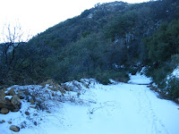
After about 7 miles I began to ear my footfalls...louder...crunching against my stride; so cool.
Frost turns to light snow, light snow fades to white and before I know it we're running in fairly deep snow! luckily its still early and we are on the protected side of the mountain... the snow is crisp and is holding our weight as we run; remember grasshopper...how to run on rice paper...
After around 2 miles we reached the Main Divide and looked upon the snow covered mountain ranges; it was a painting.. now it time to run downhill!!
Monday, January 18, 2010
Ghost Hunting at Calico 50k Trail run
Scratching, soft and faint, I reposition myself in bed, scratching, soft and faint opens my eyes in the darkness; the still, black darkness. A tree branch?, the gate? could be leaves brushing up against the bathroom window and then movement... quick and elusive, a shadow in the darkness, goose-bumps....I feel hairs rise with expectation, with caution as I slowly get out of bed… I rub my eyes; just cant seem to make out the door of my room, blackness, realizing that its open, confusion sets in as I struggle to wake up. Its not darkness in the doorway!, something else, I'm not looking beyond the doorway into the black of night but in the doorway itself, somethings there blocking the darkness beyond it and then…………….. The alarm goes off, 3:30am in Orange County and here I am…… dont even have to force it!……I smile and get out of bed! What a send off for a meeting with a Ghost town..Its always a great morning when you wake up for a race; ok I get up the same way when I'm going fishing too but today its all about running the Calico 50k.
With all of my gear carefully packed the night before it didn’t take me long to get race dressed and get out the door. Stopping by my favorite 7-11 for wake up coffee (really its chocolate and sugar mixed with some coffee) I was gone.
Its been a hundred years since my last visit to Calico, since then its burnt down and been rebuilt by Knotts Berry Farm and Im excited to see what it looks like now; located in Yermo CA its about a 1hr:45min drive so I should be there by 6:00am which would give me ample time to collect my bib and goody bag before the race.
Today Calico was honoring Joe Morris, now 83 of Daggett, he was recruited as a Code Talker after Pearl Harbor in WWII and used his native tongue to create a means of communication that was unbreakable in regards to the Germans and its allies. So that's pretty cool to see first hand.
As I arrived I met up with some friends as we prepared ourselves for today’s run, Michelle was her normal cheerful self and Charlie was as always a welcome site. We collected ourselves and gathered around the start line in the center of the street in Calico; we listened as we were wished a safe journey in the Navajo language and with a 3,2,1 it began.
The race start is a fast one, it zipped down a paved road for over 1.5 miles and many runners seem to push themselves hard here; including myself, I had seen a flash of red and knew that Michelle had rocketed herself out to the head of the pack. After awhile we finaly turn off onto welcome dirt; its deep! A truck trail full of soft sand looms ahead and you find yourself continually bouncing around to locate firm footholds. We're in the open now exposed on the valley floor and as the gentle arc of the roads leads us around the mountain range I long to hit the hills and firmer ground, up through the valleys past the aid station we enter hills and terrain and at this point I'm welcoming the change as I feel my stride increase with each firmer step.
I feel that I ran strong for a large part of the run although the sand did work my legs more than expected, Once we hit the mountainous areas the loose rocks and scrambles spoke to me in aches and pains, a little surprising to me how the sand had affected me though, I guess I need to work on this type of terrain more often. As you run through this area you see tunnels and mining roads that cover the hills like swiss cheese holes and you gain an appreciation for the miners that would toll in these mountains…without expensive running shoes and aid stations.
Some of the views here are awe inspiring, the crest of the mountains at Aid station 3 were stunning on such a beautiful morning and the volunteers were always very supportive and friendly, after a quick conversation and a few laughs I moved on.
As I ran through the hills and gorges, across the ups and downs of the martian landscape and into the last valley I was happy, tired but happy. Rounding the last turn into the town and through the parking lot I found some hidden energy that pushed me quickly to the last hill; were I stopped. This was a crazy employee vehicle entrance…a good 30 degree + pitch that spoke directly to my already aching legs, it was the last 200 yards of this race and it was going to remind you were you had come from. After a few moans and groans I pushed myself up and then entered Calico Ghost town quickly taking advantage of the downhill as I ran through the finish line……..whew…..gotta be around 5:00hrs; nope 5:20’s the sand got me… Oh yeah..and all these pictures I keep taking; and with a relieved smile it was over.
Got my meal ticket, sat with a fellow trail runner from the BAD RATS and ate chili and lemonade - Yum. I looked for my friends; said my goodbyes, and was back home by 3:00..... what a day!
Sunday, January 10, 2010
Up Up and Away the Harding Truck Trail way!
Tucker Wildlife Santuary is a 12-Acre non-profit preserve which is operated by the College of Natural Sciences and Mathmatics at Cal State University, Fullerton. The preserve is both open to the public and its free Tuesday thru Sunday…..Tucker's facilities include a small natural history museum/interpretive center, two ponds, a bird observation porch and feeders, relaxing patio and picnic areas, a small amphitheater, a caretaker's house, hiking trails, a gift shop, restrooms and an ample visitor parking lot; which for us is the start of our journey this morning.
All buckled down we set off up Harding, then continued up Harding, up harding and kept going up Harding…..there’s a continuous theme here don’t you think. Harding Truck Trail is a beautiful trail which extends from the floor of Modjeska Canyon and intersects with the large Main Divide road in the Cleveland National Forest, its about 9.2 miles one way. Harding Trail sits on the north side of the ridgeline and is a nice non-technical trail, because of its position it receives the long shadow of the morning resulting in a nice shady trail for most of your early journey.
As I reached the Main Divide at “Four Corners” I took in the views of the Santa Ana Mountains along with a few mountain bikers that had paused for a moment -(I had caught up to them earlier on Harding), with a morning greeting we moved along the Divide passing the site of the Maple Springs Aid station for the Chimera 100; memories of cold rain, wind and the tent being blown down….good times..Gooood Times!@#$ and headed up once more. At the top of Modjeska Peak we soak in a 360 degree view of everything... the snow covered top of Mt.San Antonio, Perris , Santiago Peak, Catalina, Del Mar, Encinitas Beaches….all are in play up here; beautiful. Modjeska Peak is the second highest peak at 5,384ft to Santiago at 5,687ft in the Santa Ana Mountain Range; it was named after Helena Modjeska a Shakespearean actress who lived in its shadow towards the end of her life.
After a few drinks, gels and laughs we were off again, only one way now…..down! our trip plan is now to travel south on the Divide to the Joplin Trail 6W03 then down into Jamison Spring past Vulture Crags onto Santiago Truck Trail and back to civilization on Modjeska Grade road. Joplin Trailhead sits off of the Main Divide tucked in the a ridge valley between Modjeska and Santiago Peaks; I almost ran right past it while talking with a friend (would have been in Mexico by now if he hadn’t of stopped me).
Joplin Trail is a single track trail covered in trees and shade, sidelined by moss and long grass and complimented by the occasional poison oak so be aware. Joplin is a 6.2 mile adventure, compatible to some of the best trails around. The trail is very runable, with sections of rocky downhill followed by smooth dirt or leave covered trail sections hiding under the canopies of the many trees throughout this run. As I run down it I feel like I’m in another world; hard to imagine that we are still so close to 7-11’s and constant hustling of the city below us.
The trail opens into a wonderful section called “Old Camp” with a fire pit and stream beside it; this was a meeting spot for hunters traveling the area many years ago, make an immediate left and continue up slightly along Joplin, before long you will find yourself at a flag pole, this is where Santiago Truck Trail takes hold and the “Louge” begins off to the left at a spot called Vulture crags, a hundred years ago California Vultures nested here in large numbers. Santiago trail then continues up to the right and runs directly into Modjeska Grade road. Once we reach the Grade road we are satisfied that this run has done well for us……Bring on the next adventure!!!!
This is a beautiful run, very challenging and satisfying for all. This is a 25+mile run so be prepared, there are no water stops and you must carry what you need with you.
Friday, January 1, 2010
San Mateo backcountry trail run
Just up beyond Caspers Regional park off the Ortega Hwy there’s a Candy store……….what? there really is a Candy Store! Yummy candies are prepared from scratch in addition to the standards that we all know and love jawbreakers, sours….ect. It seems a funny place to start a physically challenging, gut wrenching 21 mile trail run but the reality is that just off to the left begins the Bear Trail; that’s where we begin….
The San Mateo Canyon Wilderness makes up the southwest corner of the Trabuco Ranger District. Rugged mountains covered with chaparral and coastal sage dominate the landscape. Many deep drainages hide a lush growth of vegetation, with oak woodlands thick in the lower elevations. Narrow canyons give way to brilliant displays of spring wildflowers. Wildlife is abundant as evidenced by 139 bird species, 37 mammal species, and 46 amphibian and reptile species.
Established in 1984, this 39,540-acre wilderness has over 60 miles of hiking trails. There are four trailheads: Bear Canyon, Morgan, Tenaja and Tenaja Falls.
I and some friends met at 7:00….ok they met at 7:00 at the Candy store and proceeded to begin without me. I try to be very calculated about my planning; I really do but once you turn off on Ortega HWY it's another 15 minutes through mountain roads (which I keep forgetting to plan for!) so.......I arrived 15 minutes late and was greeted by another friend that was supporting our run by dropping water off for us at a trailhead mid-run. "THEY JUST LEFT!, if you push it you can catch them as they ascend the Bear Trail into San Mateo" He says…So my run begins…..very quickly.
The bear Trail is a beautifully conditioned trail, kept free from mountain bike overuse it’s a great trail for hiking or running. Trees provide shade for a good percent of the trail, as you ascend the sun will then take over and greet you for another good portion. This trail can be very attractive to most but you need to be prepared, carry enough water 22oz. per hour min. There are no water stops here and the trails can lead you into many of the canyons which have only a few ways out…..all of them on foot. As we ventured out we ran through many canyons, across a few streams and scrambled up some shade covered rock trails; all of which are very beautiful and forced me to act like a standard tourist (my trail camera was very busy).
All in all it was a great run, moderately challenging and amazingly beautiful. Grab a good map, layout your hike or run, find a partner or partners and be prepared! I promise that you will come out of this one exhausted with a BIG smile on your face.